Marietta · Washington County, Ohio · United States
413 Harmar Street, Marietta — the Wildermuth family house
The three-bedroom brick-foundation house Earl Adam and Sadye Irene Wildermuth bought in 1929 — three blocks up from the Muskingum River, on the West Side of Marietta — and the central physical anchor of Robert Earl Wildermuth's childhood. The family lived there over fourteen years; four of Earl and Sadye's five children were born and raised there. It is the house Robert Earl's 1989 memoir opens its sustained passages from, and the venue of the 1937 Marietta flood story when four feet of water came in on the first floor and the wooden fireplace mantle floated off its base and broke every window.
Why this place matters
The maternal-side counterpart to the paternal Eesley family's 424 N 7th Street and Highland Ridge houses in Marietta. The Wildermuth dream house — bought near the bottom of the Depression in 1929, lived in for fourteen-plus years, survived the 1937 Ohio River flood, eventually outgrown when Robert Earl shipped to the war in 1943. The street view of an immigrant-shoemaker grandson's family economic ascent.
Across generations
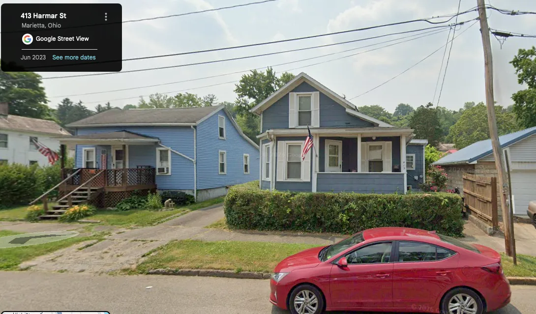
Google Street View of 413 Harmar Street, Marietta, c. 2026 — the Wildermuth family house still standing eighty-plus years after Earl Adam and Sadye Irene bought it in 1929. Blue clapboard two-story house with a covered front porch, brick foundation visible at the base (the same brick foundation Robert Earl's 1989 memoir describes as 'approximately four feet high'), an American flag hanging from a porch column, and the street's 'steady rise' visible in the background hills of the West Side of Marietta. The house, the West-Side neighborhood, and the topography of Robert Earl's childhood are all still on the ground a century after Earl Adam bought the house at the bottom of the Depression in 1929.
Alignment: First photograph in this archive of 413 Harmar Street. The Google Street View framing — front of the house at eye level from across the street — establishes the basic visual record. A pilgrimage photograph from a Marietta-visiting family member with a more compositional eye would deepen this layer further.
413 Harmar Street, Marietta, Washington County, Ohio — the Wildermuth family house of Earl Adam Wildermuth, Sadye Irene (Fleming) Wildermuth, and their five children, including Robert Earl Wildermuth (Chuck’s maternal grandfather). The address is the central physical anchor of Robert Earl’s childhood and the venue of some of the most vivid scenes in his 1989 memoir.
The house Robert Earl describes
In Robert Earl’s own words:
“About 1929 my mother and father were successful in purchasing a house that was always their dream house at 413 Harmar Street. This was a three bedroom house with a large dining room and a fair sized living room and kitchen. It sat upon a brick foundation approximately four feet high and was located on a steady rise three blocks from the Muskingum River.”
The Wildermuth family lived there over fourteen years — from about 1929 through the early 1940s, when Robert Earl shipped to the war. All four of Robert Earl’s younger siblings (Carl Edward, Norma Jean, Betty Joan, and his oldest sister Ruth Irene was already born by then) were either born or raised at this address. The dining room — large enough to hold “all of the furniture out” when his parents pushed it aside for neighborhood-children Christmas parties — was the household’s emotional center.
The Marietta neighborhood
Harmar Street is on the West Side of Marietta, in the section of the town historically called Harmar — the original 1787 settlement around Fort Harmar at the junction of the Muskingum and Ohio rivers. The street runs roughly parallel to the Muskingum River, three blocks back from the bank, on a “steady rise” toward the higher ground of the West Side. The neighborhood was the small-town, working-class West Side counterpart to the established Marietta business district across the Muskingum bridge, and it was a German-immigrant-descended neighborhood — Schlichers, Wildermuths, and the other 19th-century Pfalzer and Württemberger families’ descendants formed a substantial portion of the residents.
Robert Earl attended Harmar Elementary School six blocks from home, built on the high point of land at the river junction where the original 1787 Fort Harmar had stood; then Marietta Junior High and Marietta High School across the Muskingum bridge in the main business district. The bicycle his father had let him earn through a Baltimore summer of work (1936 or 1937) made that cross-town commute possible — fifteen minutes each way through the synchronized traffic lights of downtown Marietta.
The 1937 flood story
The house — being three blocks from the Muskingum, at four feet on its brick foundation — survived but flooded badly during the Marietta flood of 1937, when the Ohio River reached its highest crest in recorded history. The flood scene is the most vivid disaster moment in Robert Earl’s memoir; it has its own document page in this archive.
What the address meant
The 1929 purchase was the family’s deliberate economic step up — from the small West Side rental houses of Earl Adam’s apprentice-machinist years into “their dream house.” That a German-immigrant-shoemaker’s grandson and a Fleming-line working-class father could buy a substantial three-bedroom house with a four-foot brick foundation in 1929 — at the bottom of the Depression — speaks to Earl Adam’s steady factory wages and the family’s frugality. It is the maternal-side equivalent of the paternal Eesley family’s 424 N 7th Street house and the later Highland Ridge Road house on the Eesley side: the address where the children’s adult identities formed.
The house outlasted Earl Adam and Sadye. By the time Sadye died in 1976 and Earl Adam followed in 1977, the family had moved to 320 Harmar Street — a few addresses up the same street — where Robert Earl’s blind brother Carl was living with their father in old age.
The current state of the house — c. 2026
The house at 413 Harmar Street still stands. A Google Street View capture from c. 2026 — embedded above in the visit record — shows a blue-painted clapboard two-story house with a covered front porch, an American flag hanging from a porch column, and the same brick foundation Robert Earl’s 1989 memoir describes as “approximately four feet high.” The West-Side topography — the “steady rise” Robert Earl named — is visible in the background hills. The neighbors’ houses on either side appear to be of the same early-20th-century vintage; the West Side of Marietta has retained its 1900s–1930s building stock.
The house has presumably been owned by several families since Earl Adam and Sadye Irene moved out (the family had relocated to 320 Harmar Street by Sadye’s 1976 death). Its current owner is not documented in this archive.
A family-pilgrimage photograph of the address — in the tradition of the Rielingshausen / Grossaspach Wildermuth-origin photography from Robert Earl and Sandra’s 1993 trip — would deepen the record. The Street View is the documentary anchor; a family-eye photograph is the next contribution.
Source: Robert Earl Wildermuth’s 1989 memoir, the opening passages on his Marietta childhood; family memory transmitted via the memoir’s framing.